Category Archives: Old articles

Articles from the old IMC website

Four go mad in the Dolomites (& Ortler Alps)

The start was from Martin’s house in Ipswich on a grey Thursday afternoon where (under strict orders of no boxes or crates) Steve Gray’s C5 was loaded to the gunwales with all the paraphernalia for a 6pm start. Twenty-four hours later a very tired team pulled into the campsite at Madonna Di Campiglio whacked up the tents and cracked the first beer. In the intervening 1200 miles the main excitement had been the destruction of the nearside wing mirror with an impressively load bang whilst passing the French equivalent of road cones at 70mph – thankfully the car’s owner was driving at the time! Gaffer tape and a vanity mirror got us as far as the Citroen garage at Innsbruck

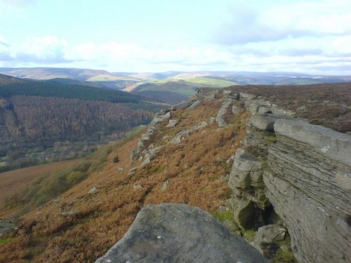
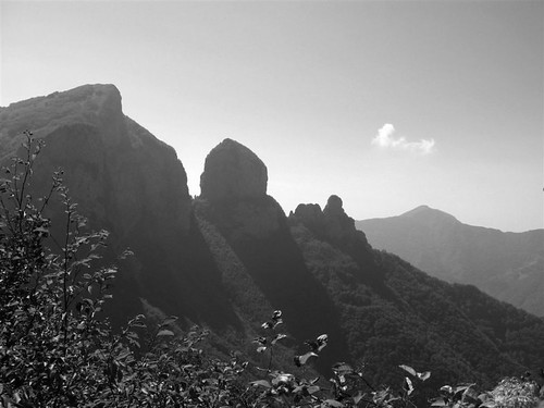
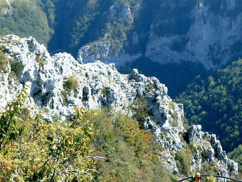
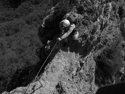
The following day we decided to start on the Via del Bocchette Alta (or Bugatti alta as Martin insisted on calling it), the classic via ferrata (Iron way) of the Brenta that we planned to do in two days. That afternoon after much faffing and lunch-shopping we headed up the Groste cable car (bliss!) and headed off for a short via ferrata to get us in the swing of things before heading back to the Graffer hut for the evening. A good meal, another beer and a bunkroom to ourselves felt pretty luxurious by alpine standards and we had a relatively relaxed 6am start to look forward to as well. The following day we were out by 6.30 and heading up to the ridge where the Bocchette Alta starts. Initially it’s over ugly ski-developed land but soon we were on an amazing limestone pavement and were being overhauled by a fit Swiss party. At the ridge we started to see cables on the harder sections but the tricky terrain is about Grade 1 or 2 scrambling and you can avoid the cables if you like. Three and a half hours later and we descended rickety ladders to the first col – the not-very-Italian-sounding Bocca Del Tuckett – and eyed up the climb to the day’s high point. We slogged to the top via a series of short ladders with a lunch break halfway and soon we had the plateaux in view where our destination – the Alimonta hut – is sited. So far it had been a lot of walking with a little scrambling and a few ladders, but the next two hours were a series of steep and exposed descents and ascents on ladders in amazing terrain.


via ferrata
Via Ferrata (click on any image to view in Flickr)

It was with some relief that we eventually spied the hut around 4pm.
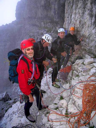
Steve Gray nipped inside with the kitty and soon returned heavily loaded and with a large grin on his face – a ‘birra grande’ turned out to be a full litre – but we weren’t complaining.


4 having a beer
4 having a beer

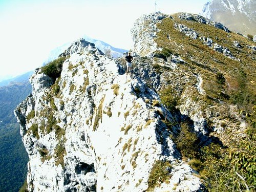
Another fantastic hut with a menu, comfy bunks and copious beer meant the 6am start wasn’t too onerous the next day and we set off back to the col we’d left the previous day and then up a series of ladders. This section was the most spectacular of the trip so far with narrow ledges, rickety wooden walkways, huge drops and views of the big limestone spires and faces, all well-protected with steel cables. 10.00am saw us at the end of the Bochette Alte and all we had to do was get to the Groste cable car back at the start of the route. Thankfully there was an ‘easy’ way back via a lower-level path but still it was a pretty shattered crew who got back to the tents at 6.00 that evening.

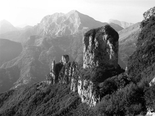
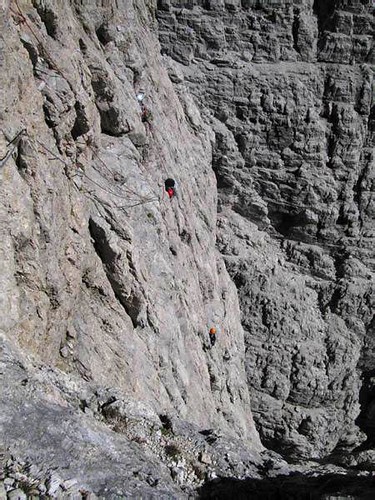
The call was for a day off so we headed off for the fleshpots of Trento (surely the underwear capital of the area given the number of such shops) before Martin started talking us into the next objective – the Fehrmann route on a limestone spire called the Campanile Basso.


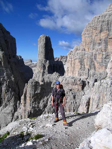
Steve C with The Campanile Basso behind

Martin sagely kept quiet about some of the details of the route, sticking to the line that it was a classic and that he’d done it before without any trouble. It was only after the plan was agreed that it transpired that we had signed up to 13 pitches of up to VS and an abseil descent. The Fehrmann finishes 4/5ths of the way up the Basso and, if you’re quick, you can continue up the ‘easy route’ to the top. We reckoned we’d need to finish the Fehrmann by 1.30 to give us time to get to the top and back down for dinner.


Fehrmann
The start of the Fehrmann at 7am in the mist

The day didn’t start too well when we followed a knowledgeable-looking Italian team in the fog to completely the wrong place – they were back down before we’d left the ground though and soon we, along with the Italians and a team of four Germans in their 60s, were at the proper start and the Italians disappeared upwards. We got going too, moving as fast as we could and placing what we thought was minimum gear. The Italians and Germans though placed virtually nothing, typically just clipping three pegs on a 40m pitch and soon the Italians were out of sight ahead and all the Germans had overtaken us. 1.30 was now looking optimistic and a small HVS (at least that’s my story) diversion didn’t help. Ultimately we all got to the ledge by 4.30 to see the racing German pensioners descending off the summit above us. Four abseils later we were back on the Bochette Alta, the last half-mile of which constitutes the start of the descent route. A thirty-minute gallop down the moraine and we made the hut five minutes before dinner finished at 8.00 – a memorable day out and at least we beat the Germans back to the hut!


Steve, Carol & Martin 12 pitches up on the Fehrmann

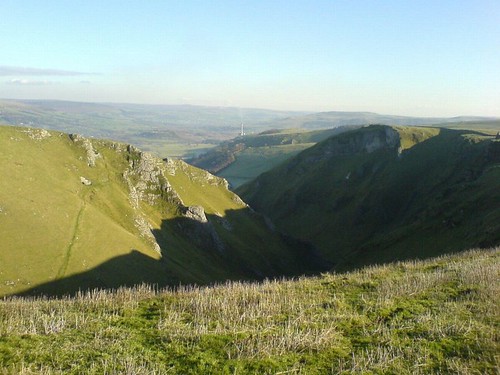
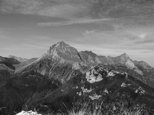
Having warmed up in the Dolomites, the decision was made to head to higher things and, after much faffage, we decided on the Ortler Alps just 150k or so North of the Dollies. After seven hours of driving over three passes, some very narrow roads, more hairpin bends than you can shake a stick at and huge numbers of mad motorcyclists and fit pedal-cyclists we ended up at Trafoi just outside the National park area of Sulden – where hotels are permitted (and rich tourists!) but camping clearly constitutes a danger to the National park – Grr.

We headed up the next day to the Dusseldorfer hut which, according to our guidebooks, sat near the foot of a set of glaciers running down from the Hohe Angelus and the Vertainspitze, both around 3500m. Sadly, global warming had done its thing and both glaciers had virtually disappeared to the particular disappointment of those in the team who had bought new crampons and an axe. Still, we were up at 5 the next morning and set off for the Hohe Angelus via the newly exposed rocky ridge and then, on a point of principle, onto the remaining snow and ice to the top. At 9am we were on the top and then it was down onto a huge dry glacier on the far side, clearly melting fast. Dropping the sacks at a col we nipped up the Vertainspitze too before a consultation of the map revealed we had 1000m of descent to make to get back to the chairlift home. With much groaning of knees we slogged downwards over hideous chossy moraine and it was a very relieved team who sat down at the lift station. Here some confusion was caused by the waiter being under the impression that we would like four bears – you’d have thought these dashed foreigners would understand their own language wouldn’t you?

We did a bit of cragging at a very chossy little crag on the Tuesday where we watched a local guide teach belaying techniques that would give Libby Peters a heart attack, and then on the Wednesday went to Bolzano where we took in the Museum where they have ‘Otzi the Iceman’ – well worth a visit.

The plan was then to go back up to a hut and do the big peak in the area, the Ortler, but 2 days of solid rain and a poor forecast decided us on an escape to drier weather cragging in France. Sadly, by the time we got to Dijon it had been raining all day there too and showed no sign of letting up – the restaurant for the evening even had a fire burning in the hearth. The forecast deteriorated further overnight so finally the decision was made to run for home. All in all though a good trip with, for me, the highlights being the fantastic rock and scenery of the Dolomites.

How Gunni grew wings…

Gunni Page – January 2008

A voice behind me piped up cheerfully: “Here are my lucky nuts, Gunni.” I choked on my muesli…

It was the morning of the first day of the beginner’s follow on meet and I was innocently sitting outside my tent having breakfast. Having tentatively put the word around that I was hoping to start leading some easy routes soon, Caroline had very kindly offered me some of her surplus gear to get my rack started. However, as this conversation had been had a) some time ago and b) over a pint in the pub, I hadn’t expected her to remember. But here she was, true to “Madame Pres” form, crab with the lucky nuts in hand and looking very surprised at the sight of me with milk dribbling down my chin… There was no getting out of it now, was there? Me and my big mouth…

Though I had studied the guidebook for the area carefully beforehand and had marked some suitable – or so I thought – 1st leads, the masses of climbers present at that day’s chosen venue, The Roaches, meant that I didn’t actually succeed in leading anything that day. I still managed to second several nice routes, though, and enjoyed some great climbing. So, lucky nuts dangling unused off my harness, I retreated back to the car that evening, feeling a mixture of disappointment at not accomplishing my objective for the day and (ok, I admit it only to you) a little relief at not having had any difficult lead situations to deal with, as, of course, I wasn’t nervous about my first proper lead AT ALL.

True to Staffordshire spec, the next morning dawned a bit grey and breezy. And things were to get worse… No more spilt milk actually, but Johnboy announcing cheerfully that the chosen venue for our group for the day was in fact Hencloud, as he wanted to meet up there with Nick, who – since leaving the flatlands of Suffolk for sunny Sheffield in the summer – is now a “crag local” (who said we’d be bitter??). Well, the routes at Hencloud have a reputation for being hard for the grade, the whole crag is much more exposed and there aren’t more than a handful of easy routes. So I mentally prepared myself for a day belaying and bonding with my duvet jacket.

Cue the ever-supportive Clio, who was having none of it. Once arrived at the crag, but not before giving a very impressive and gutsy performance trying to lead “Reunion Crack”, a VS 5a**, she bullied me (in the nicest possible way) into trying the very short and low grade “Chockstone Crack” as a first lead. Well, talking of trying to get off the ground! I just couldn’t do it and felt disillusioned and desperately sorry for Clio and Steve, who were trying their best to talk me up the rock, all the while getting colder and colder and probably thinking “What IS she doing? This is a “Mod”!. I was a little happier when Steve tried the first few moves himself and agreed that for someone my height they were hard and maybe we should move onto another route instead (no offence taken, I always knew that one day being a shortarse would come in handy). So, off we all trundled to find Johnboy and Nick, who were climbing at the other end of the crag. Right, I thought, this weekend’s plan is going nowhere…

A quick check of my pack produced some much-needed sustenance and a can of Red Bull. I can only put it down to this liquid refreshment (and, ok, a little more bullying from Clio) that I soon found myself gearing up to lead “The Arête”, a superb looking 30m long HVD***. Well, what can I say: while Clio belayed me, Steve soloed up beside me to give hints and moral support (which was MUCH appreciated), I placed every bit of gear I had and then some, thoroughly enjoyed the experience and finally topped out with a big whoop. What a feeling! Having set up the belay I quickly brought Clio up. I am certain that by that time she well and truly regretted her earlier persistence as she had got quite cold belaying me and was now having to take my rather well placed gear out as well. Luckily, the stiff breeze took all swearwords, which might have been muttered, away before they could reach my delicate ears. Seeing as my grin went all the way round my head at that time, I probably wouldn’t have heard that well anyway. Eventually Clio joined me and Steve, we broke down the belay and set off down the crag – the perma-smile still plastered across my face and the lucky nuts dangling happily off my harness, this time used and abused.

Now, why exactly I bottled out of leading an 11m short route, graded at a mere “Moderate”, to then successfully lead an “HVD” route three times as high an hour later, only God and the makers of Red Bull will be able to answer. All I know is that I thoroughly enjoyed my first “proper” lead and for this reason my thanks go to:
Caroline – for the kind surrender of the lucky nuts
Steve – for reassuring me all the way up
Clio – for being the nicest bully I know
The makers of Red Bull – for giving me wings

Bring on the summer – the lucky nuts and I are ready! (And I will remember to bring something non-spillable for breakfast as well as plenty of “liquid wings”!)

Rain Doesn’t Stop Play in North Wales – Jan 2008

Trip report 12th January 2008

I was going to write to the editor demanding more trip reports in The Newsletter, but then I thought perhaps I should stop griping and write one myself.

On the Saturday two cars set out from Ipswich at four o’clock in the morning, with a total of six right-eyed and enthusiastic outdoor types on board. Shortly after nine o’clock we were in the Ogwen Cottage car park drinking tea, convincing ourselves that the weather wasn’t too bad and being faintly surprised just how many people were parked up and on the hill already. Five of us calling ourselves climbers and one of us calling himself a hill-walker; we chose a couple of grade three scrambles on The Milestone Buttress as our objective and set out accordingly. We started at the base of the right hand side of the buttress and roped up in two teams of three. Interesting and exposed moves kept us focused at half height. I failed to persuade the other team that the corner chimney of Milestone Direct was an entertaining diversion as we tackled the easy chimney to the right. Well, I still contend that it would have been entertaining to watch.

A little higher is the Milestone Continuation, which turned out to be a pleasant scramble as well, but by the time we got above the difficulties the rain had returned to encourage us to find a way down. Traversing and descending in the rain got us quickly and perplexingly back to the road with plenty of daylight remaining.
After some route finding difficulties in Bangor, and mixed navigational success to and from the supermarket, we arrived at Jesse James’ bunkhouse as the weekend’s main weather event built in intensity and then continued with horizontal rain into the next morning.

Sunday morning and the others elected to go for a low-level walk, but Andy and I were convinced that the weather would be nicer at Tremadog. As Andy drove through the rain near Beddgelert we managed to convince ourselves that it was easing. Arriving at the crag we were surprised to find Eric’s café and the car park closed. Astonishing in what must surely be peak season there! Gearing up it really did seem as though the rain had eased off and we elected to climb Hail Bebe, which had the twin virtues that it was ‘only a v.diff’ and that I could find the start. I have to say that I’ve always been a fan of Tremadog’s mudstone, but I admit that in the wet it isn’t the grippiest rock that I’ve ever climbed on. It was, for me, exciting enough! Soon, Andy was topping out in the gale force wind on pitch 6 as the rain started again in earnest. The wet and slippery descent was marginally worse than the usual summer conditions, but only just, and we were soon “gear shop traversing” in Beddgelert.

Monday dawned slightly drier and while the rest of us went for a walk near Llanberis, Martin and Andy spent the day at the local climbing wall before heading home.

For me it was great to get out for the first time in several months, and a bonus that we actually got some climbing done.

Martin’s Peak District Trip

Martins Peak District Trip, November 2007

Grand Adventures!

Martin Stevens – December 2007

I decided on a whim, and at quite short notice that I fancied a few days away. Having bought a smaller, lighter and less-bulky-when-packed tent just for motorbike touring and having just picked up some bike-touring luggage what could be better than just giving it a go? The weather forecast was good enough so I decided to go.

So I did. I prepped and packed and on Tuesday 13th November I loaded the boxes, clicked them into place, strapped on a drybag with the tent and my enormous full-on sleeping bag in it and headed for the Peak. Within 15 minutes I was back home and picking up my fleece jacket before heading off again.

I paused and fuelled right up just before leaving Ipswich and headed west before turning north up the M1. Next stop, fuel in Chesterfield. Onwards into the Hope Valley.

I arrived at Hardhurst Farm, checked in at the farmhouse and parked the bike. I put the tent up – easy but why do they never provide enough pegs? Still, it was Hardhurst Farm and I’ve never not been able to find tent pegs just for looking.

Here’s the Beast with the tent pitched behind it, and in the far background the pimple is Win Hill.


The beast by the tent
The beast by the tent (click on any image to view in Flickr)

Off to Hope (the village, not a state of living) for supplies in what remained of the daylight. The walk back was in the dark, by which time it was suppertime. That being done, I retired, a little fatigued, for a little lie down, a glass of wine and a good book.

Wednesday 14th November

A nice day, as forecast. Breakfast out of the way, flask made and lunch packed and it was off to Bamford Edge, rock shoes and helmet also packed. Bamford is a favourite crag of mine. I chose to walk. After all, the crag can easily be seen from the campsite so how far can it be?

It took me the best part of a couple of hours to actually arrive at the crag, but that does involve pausing to take some pictures with the crappy-cam, pausing to find out that my SLR has film but the battery has gone flat so nothing works, navigating my way and pausing merely to wonder why I didn’t just ride the bike to the parking place.


Loose Hill
Here’s Loose Hill looking good in the morning sunshine

Having crossed Yorkshire Bridge it was a haul up the ‘New Road’ beneath Bamford Edge to the approach path.
Although Bamford Edge is on Access Land there’s no easy approach except at the approach paths, the surrounding fences are barbed wire in good order and it would be a hack through long bracken up a reasonably steep hillside.


Toward Bamford Edge
Toward Bamford Edge

It’s not called the Crappy-Cam for nothing!

Having arrived I paused awhile to take in the view before dropping down to the foot of the crag for some easy soloing.


Looking West
Looking West

Looking South
Looking South

No pictures of me soloing as the crag was deserted and I’d have struggled to climb and operate the camera.
However, I did manage to take a picture of a squeeze chimney that I struggled through…


I fitted through this . . .

It was a tight squeeze, and I found that whilst Paramo fabric is tough stuff, sometimes it’s not tough enough!


. . . but not without some holes

I had a grand time on the crag, climbing whatever I fancied and feeling no external pressure. I did on several occasions look at lines and twitch, and then make myself walk away rather than trying and finding out the hard way that I wasn’t up to the challenge. I did manage the Severe 4c start to Gangway after offering up and backing off a couple of times, the success of which pleased me but did indicate just how out of practice I am and really did discourage me from trying anything harder.

Given the time I’d taken to get to Bamford and not really wanting to walk too much in the dark I headed back in good time and was happy with the climbing that I’d done. I walked back via Bamford and Thornhill villages and reached the campsite just before dark.

Hot tea, hot meal and then despite the proliferation of stars in a clear sky the cold drove me to the warmth of my sleeping bag.

Thursday 15th November

It really was cold in the night; in the morning there was every sign of a serious frost.


Frosty morning
Frosty morning

The contents of both bottles were frozen solid. Fortunately I have mastered the art of drinking black tea. A hot breakfast, several cups of tea and the making of a flask had pretty much exhausted my gas bottle so today’s walk (I certainly wasn’t climbing with the rock likely to be finger-numbingly cold) had to involve guaranteeing a supply.
I decided that given the superb blue-sky and no wind conditions that higher ground was in order. I packed up, carefully not packing my SLR – but I did pop the battery in my pocket in the hope, which I did not expect to be realised, of being able to pick up a replacement.

I headed into Hope Village, did the round of the shops there and picked up some extra lunch, a supply of gas and of al things a camera battery, and had a chat with the chap running the outdoor shop. He was very keen to suggest that the Hebrides is a fantastic place to visit. I’m sure it is, but that will have to be another Grand Adventure.

By the time I’d made my purchases and was ready to leave I didn’t think I’d have enough time to take in the walk I’d originally intended and still get back in vague daylight so I passed on Win Hill and headed straight up Loose Hill. Conditions were excellent and it didn’t take long for me to feel the need to pause to take of my fleece.


Along Loose Hill to Mam Tor

Given the quality of the weather I was bit annoyed that I’d not made the time to go back and get the SLR, but that’s making a choice in the morning for you.

I headed along the ridge to Mam Tor which was quite busy, especially for a midweek lunchtime.

On the descent I spotted a load of features set into the descent path and paused to take some pictures.


face

Plough
Face Plough

Torque

Hut
Torque Hut

From Mam Tor I headed around to pass South of Winnats Pass, where I paused for a late lunch.


Winnats Pass
Winnats Pass

Skirting around Pindale I worked my way down via a grotty quarry and behind the cement works and into Bradwell before taking footpaths back to the campsite, where I arrived just before dark.

It’s much easier to open tins of things with a can-opener, so I had to go off to Hope and buy one. That done, I made a good supper and retired to the warmth of my sleeping bag to drink tea and ponder the maps for ideas for the next day. Sadly the confines of the tent just didn’t lend themselves to good map scrutiny so I had to head off to the pub for a while, merely to have a big enough table to spread out two maps. Drink had nothing to do with it.
Maps consulted I lingered a while and then retired to bed where I drank some wine and before having a good nights sleep.

Friday 16th November

A slow start after warmer, damper night – no frost this morning. In my usual, ‘Oh, rain’ fashion I went back to sleep for a while in the hope it would stop – and within the hour it did.
After fast breakfast and packing for the day I headed out up towards Bamford again. Rather than climb (certainly too damp to be fun, I’d thought, and not even packed rock shoes) I headed over the moor behind the crag and eventually found each of the five cairns marked on the map. From there I headed down gently before heading up hill again and traversing along the foot of Stanage Edge. I made my way up around Stanage End and walked along the top of the crag. I was a little surprised to see half-a-dozen pairs of climbers but there are clearly plenty out there that are hardier than I.
At the Popular End I paused for a while after a late lunch to have a chat with a couple of paraglider pilots before descending and heading into Hathersage.
Bargain hunting was unsuccessful and it’s hard to have as satisfactory a fondle when you’re on your own so then I decided to head back to the campsite via the Derwent Way that runs south of the river. Its not that far but my goodness they do like their narrow gates and the path was very muddy in places. I didn’t get back to the campsite until after dark.
After some revitalising hot tea I took a stroll up Alston Lane and away from the light pollution. A fantastic starry night, although very cold but by this time something alcoholic was keeping me warm.
Back to the campsite for supper and wondering where all the caravans had come from. The whole site was crowded with them.

Saturday 17th November

A fine, fine nights sleep – and then I find the onsite cafe is open for breakfast! So I did the decent thing and went for the works. Eventually I dragged myself from the warmth of the cafe and prepared for a day out. I’d considered wandering south into the white peak instead of always heading north, and today was the day.
Over Rebellion Knoll and slowly the overcast sky clears as I head into limestone country, but the wind stays cold.
I headed for Silly Dale, just for the name and then for St. Peters Stone where, once I’d ascended, I stopped for lunch. Of all the places to take new climbers, St. Peters isn’t high on the list – I’d call it a tottering pile of choss but apparently “It’s really good for hard won belays” which is why the team of ML trainees were there. In talking to their instructor apparently there’s a cave beneath the Stone that’s bigger than the Stone…access via a metal plate in the cleft that forms the easy way up, if you care.
I took a parallel route back to the campsite, encountering some very friendly horses and seeing a pair of kestrels hunting the same small patch of ground. By the time I was back I was getting really fed up with the “squeeze” type stiles. They’re really not designed for the slightly less than streamlined and I encountered entirely far too many of them.

Back in good time although my feet were really beginning to protest at the amount of walking the trip had requested of them. I got to the point where it was easier to just keep gently walking around than to sit or lie down. The gently walking did take me back up Aston Lane a good way, where I got a good view of fireworks over Bradwell, although the stars weren’t nearly as good as the night before.

Sunday 18th November

I’d woken a few times in the early morning to the sound of rain, and it was cold too.
Eventually I was forced to get up despite the patter of the rain sounding worse, although as it always does it sounded far worse inside the tent than it actually was outside although at some point snow had fallen and some ice was still gathered in the creases of the tents flysheet. On the higher ground I could see that the snow had settled or at least not melted yet and the hills were white.

I found the cafe was open, and it was raining…a no-contest decision and I once again went for the cafe breakfast.
Having had a fortifying breakfast I couldn’t really not go out into the snow, at least for a short walk so I packed lunch and headed for Win Hill, well wrapped up against the rain and cold.
Above about 450m the rain stopped and became sleet, then snow, and snow had settled


Snowy path up Win Hill

Visibility started to become reduced and became correspondingly more careful with my navigation. I prevailed (it wasn’t that hard) and reached the summit where, given the almost complete lack of view I failed to stop and headed on down straight away, looping around towards the Ladybower Reservoir through the woods. Across Yorkshire Bridge and then I took footpaths down towards Bamford. Being suddenly followed by a flock of sheep isn’t the sort of thing you want to have happen to you and I’ve no idea what triggered it off but the whole flock just started to follow me…


They just followed me

Being a town-dweller I’m unused to such things and had to pause in the Outside cafe for a late lunch to help settle my nerves before heading back to the campsite. I’d had my fill of the Derwent Way the day before so took what seemed the expedience route along the road, a dull haul in the failing light.

By the time I got back, if it hadn’t been so dark I could quite well have packed up and gone home but finding a bottle of wine lurking in the foodbag put a new complexion on the matter. The gentle patter of falling snow as the temperature dropped just assured me that I’d made the right decision not to motorcycle home that night.

Monday 19th November

Packed up and travelled home after a slow start, taking it easy until the mist cleared once through Chesterfield.
In the vast scale of things just a few days away in the Peak but sitting here reading my diary notes, editing the photos and thinking back…what a Grand Adventure!

Martin

Peter and Louise in Knoydart

Peter and Louise head into the wilderness

Peter Krug – December 2007

Bloody Cameron McNeish

…… I muttered under my breath as I staggered under the burden of a heavy
rucksack along the picturesque …… nay stunning banks of Loch Hourn
towards our base-camp in Barrisdale. This was the culmination of what had started, a few years ago, as an innocent evening’s entertainment watching the TGO
editor’s series of programmes entitled “Wilderness Walks”. It was a particular episode, a backpack with the late Chris Brasher, which sowed in my mind the idea of visiting Knoydart, one of the last wildernesses in this country. And now, on a sultry mid-summer’s evening, it was happening.

This was a long-planned and well thought-out trip……………… not. The
destination was decided whilst on the M6 the previous evening when we obtained
the latest satellite weather forecast from Louise’s father via mobile.
It indicated that the further north and west you went the more promising
was the weather – so that’s the way we headed. So well thought-out was it that the next day we needed to pop into Fort William for some provisions, having only just survived a MidgeCom 10 attack (on reflection later downgraded to 7) whilst
erecting our tent at the Red Squirrel campsite in Glencoe the pervious midnight.

Now we were on the way, and as we walked we came across a couple of
sights that sent shivers up my spine. We met and chatted with two sturdy
male backpackers on their way out and they looked how would you say it . . . a bit tired . . . well actually they were chinstrapped. One of them
even admitted to being “shattered” and was asking how much further there
was to go (he could be excused as he had backpacked all the way from
Fort William in four days).

The walk-in from Kinloch Hourn was, allegedly, only six miles and included,
allegedly, only about 300metres of ascent and descent, but it felt a
whole lot further.


Loch Hourn
Bonnie banks of Loch Hourn (click on any image to view in Flickr)

However, it was very pretty and the whole feel of the
place was unusual in a way that I couldn’t quite fathom. In a way it
felt almost sub-tropical, perhaps because it was a humid evening, but some
of the plants and trees really gave you that impression. You could certainly tell that they got some rain around there.


Loch Hourn 2
Walking by the Bonnie banks of Loch Hourn

As we turned the last
corner into Barrisdale Bay we passed a sign claiming that this was a busy
area and asking us to camp by the bothy a mile further, and a long
mile it seemed. Busy my arse – we reckon that there were fewer than 15
people there – have they seen the Bigg Market on a Saturday night!

We found the bothy, put up our tent and cooked some well-earned nosh; it was 8.00 pm but, being high summer, it felt like it was mid-afternoon.


Looney Bin
Looney Bin

It was a great place to be with the impressive Luinne Bhein (renamed Looney Bin) towering above us one side, Barrisdale Bay and Loch Hourn on the other. As the sun set we discussed the next day’s options in terms of what mountains to climb and by which routes, and a great philosophical debate raged over whether or not we could call
camping by a bothy with running water and a loo “wild camping”.


Home, sweet home
Home, sweet home

The next morning was bright, warm and extremely humid, and we could
see that there was a build-up of cloud. Well, “let’s go for it” we thought,
and today’s main objective was Meall Buidhe – the only
Knoydart Munroe to have escaped Louise so far. We headed up past
some woods into the valley known locally as the Gleann Unndalain and up
to the bealach (col) known as the Mam Unndalain. It was hot work
climbing to the 500-metre point of the bealach; we stopped only to store the
contents of our Camelbacks in our stomachs so we could refill the
former from the stream as we were not sure when we would next find water.

However, the clouds were rolling in and as we were reaching the bealach
some of the tops were periodically disappearing from view. We then hung
a right (turned westwards) and tried to find and follow the ridge
towards Luinne Bhein that those who were paying attention earlier will
know as Loony Bin. We had some lunch on the way enjoying the views but
as we reached the base of Loony Bin, just 90 metres short of
the summit, Louise dropped the bombshell that to climb Meall Buidhe we
would have to hang a left (turn southwards), drop 250 metres to a col
and then climb again.

I surveyed the route ahead and, after studying the nearer territory,
realised that Meal Buidhe was a very long way away, that there was a lot
of up and down required to bag this one and that we would have to
return the same way. I said, “Let’s go for it”. Now I am not sure that
Louise was too keen on this and the weather was not improving but,
nonetheless, we trudged downwards as this was the Knoydart Munroe that
Louise needed to bag. It did not take too long to get down to the
bealach and with no further ado it was up the other side passing Meall
Coire na Gaoithe n Ear (what a mouthful!) before descending and then
descending and then ascending and descending ………….. You get the drift I
said there was a lot of upping and downing and there was.


Meall Buidhe
Home, sweet home

When we reached the base of Meall Buidhe itself there was some interest with a
bit of scrambling which took us up the final 100 metres to the top of
Meall Buidhe, although naturally the actual summit was at the far end of
the top (nothing is given away easily in Knoydart).

Having achieved the top and with a bonus of some splendid views of the
hills of Knoydart and the Glen Shiel to the northeast and the Islands
(Inner Hebrides) to the west we had a snack before reversing the four
kilometre walk right back to the base of Looney Bin that we had left some
two hours previously. This was purgatory, but hey, we hadn’t come to
Knoydart expecting an easy ride. The final pull up to Loony Bin was
uneventful and we were treated to similar views to those we had enjoyed on
Meal Buidhe but there was weather in the air so we did not hang around.

We continued along the ridge rather than reversing the route for
variation and descended down to the bealach (Mam Barrisdale) heading
roughly in a northeasterly direction. We were coming down just in time
as the weather was closing in around us, and by the time we reached the
bealach it was raining. But the path was a good one and I had the shock
of my life when Louise “beep-beeped” me in Roadrunner fashion indicating
that I should speed up. This is most unprecedented methinks! As we
reached the glen I was surprised to see about a dozen deer grazing in
the field immediately behind one of the houses. “It was only about 7 pm
and the conditions were fine so why come so low” I thought!

We quickly got together our food and stove and headed towards the bothy
to cook our supper and chat with the other folk there and get out of the
rain!

We knew the next day was going to be a big one if we were to bag Ladhar Bheinn and
backpack out, and so it proved to be. Careful route-planning and debate
raged as to which route we were going to take and in the end it was
decided that we would cross the bay and find our way up Creag
Bheithe, the nearest of the two north east ridges of Ladhar
Bheinn. The next morning revealed itself to be overcast with the tops
occasionally disappearing into the clouds; after breakfast we set off,
for some reason deciding to head up to Mam Barrisdale thus reversing
the previous days retreat from the hills!

A steady pace up the easy path saw us well on the way. We were
looking for an easy route up to the eastern ridge of Ladhar Bheinn (Stob
na Muicraidh) but none of the options proved attractive so we carried on
up to Mam Barrisdale where we met a couple of chaps whom we had met the
previous day. They were camping somewhere below the bealach and had
enjoyed quite a stormy night. We briefly joined forces as we hung a
right and headed northwest to pick up the ridge below Stob a Chearcaill,
the most south-easterly of the tops around Ladhar Bhein. A
short scramble saw us skirting below this top, then we contoured
around to the Bealach Coire Dhorcaill where we finally joined the ridge
leading to the top. We weren’t quite there yet though as there was still a
fair amount of upping and downing, some mild exposure in places and not
to mention a couple of false summits before this peak was officially
bagged. We were now at what Ralph Storr writes as the best viewpoint in
the Western Highlands – yeah right. “So why does grey cloudy stuff
constitute a great viewpoint?” I grumped.


The best view in The Western Highlands

Now the fun began. The peak of Ladhar Bheinn is quite complex so in the murk that surrounded us we weren’t quite sure where the descent was.
There were some big drops around as well to add to the spiciness of the
situation. We were looking for a ridge descending in a northeast
direction, which was all very well but we couldn’t see “Jack”. We carried
on along the ridge for a while before Lou decided that the descent route
lay elsewhere and headed back past the summit before spotting it
(actually by standing above it). It was not a very enticing prospect
involving a lot of scrambling and more exposure than Lord Snowdon
could shake a lens at, but it had to be done. Unfortunately we dropped
below the murk quite soon and so we could see where we would fall, but a
steeling of nerve and steady progress saw us down safely onto more
amenable ground.

However, the day was passing quite rapidly. It was gone 3.00 p.m. and we
still had a fair bit of walking to get back to Barrisdale, and then there was the walk-out.


The long walk home
The long walk home

So we legged it back to Barrisdale in double-quick time. By now the weather had cleared but there were no thoughts of heading back up to confirm whether or not Ladhar Bheinn was the best view in the Western Highlands.

Having reached the tent the cunning plan was to drink some tea and finish
the provisions whilst packing the camping stuff into the items of torture that
were our rucksacks. We left the campsite at about 6.00 pm and the views
were even better than they had been when we arrived. Unfortunately, Lou’s toes
were giving her grief; surprising really as, after all, we had only been walking for something like eight hours and there was only about another four more to go. She had decided to break the walk-out into six stages and had rationed herself to only one strop for each stage! In spite of this we made it out in slightly less than the 4
hours. We both felt sad to leave such a remote, rugged yet beautiful
place and head back to the thriving metropolis that is Kinloch
Hourn. It was certainly hard work but every step was worth it. Try it if
you feel you are up to it – you’ll love it!

Apuan Alps Trip

Adrian and Kearton take on Italian via ferrata

Kearton Rees – December 2007

Very early one September morning Adrian, the Fagg clan and I trooped off to Stansted airport en route to the Apuan Alps (Alpi Apuane). Despite what their name suggests, they are not part of the Alps but a small range of mountains on the west coast of Italy just north of Pisa & Florence, south of La Spezia and east of the main Apennine range. Our base was to be Lucca, an interesting old walled city, thirty minutes north of Pisa. This was my second trip to the area whilst Adrian had been there many times. On my previous trip we had walked many of the peaks in the area, including the highest in the south of the range, Pania del Croce (1880m). This time the aim was to do a few of the via ferrata in the area.

The first day we decided on the easiest via ferrata in the area on Monte Sumbra. Due to a late start and some confusion over the map labelling we reached the starting point next to the marble war memorial in Arni at 1230. The route took us past the church, up some steps and onto a well-worn path up to the edge of a ridge. On the first part of this, despite the strong midday heat we wished that we hadn’t worn shorts as the path wound its way through a field of gorse bushes. From the ridge we got excellent views across the valley and up to the marble quarry at the base of Monte Fiocca. The slog up the ridge, on uneven ground, to the traversing path, was long and slow and made me wish I’d done more fitness preparation. Once on the traverse we speeded up a bit with the occasional misdirection. On the whole paths in the area, maintained by the Italian Alpine Club, are well marked – although sometimes the signs are more visible if moving the opposite direction. By 4 p.m. we had traversed around the top of two valleys and through a wood. At this point looking at Monte Sumbra we realised that there were another two valleys to pass plus an ascent before we would even reach the start of the via ferrata, so we decide to turn around and treat it as part of our fitness preparation

The weather forecast had promised three good days before bad weather arrived, so the via ferrata routes had to be done at the start. The next day we headed to a car park near one of the highest buildings in the area. This allowed us to avoid a significant ascent at the start. The route took us up to the pass, Calare Mattanna, from where strips of red and white paint indicated our route down from the pass, starting with an interesting scramble followed by a slow descent to a path past the base of the main face of Monte Nona. This is the most significant climbing wall in the area, but aside from one rope leading to nowhere in particular in the middle of the face, we couldn’t spot any routes beyond about 6m above us. The path crossed a small footbridge that spanned the chasm between Monte Nona and the ridge that holds the cylindrical Monte Procinto and its smaller, but similarly shaped, neighbours Procinto Bambino and Bambinetta. (Seen below from Monte Forato ) The via ferrata on Procinto is thought to be the first one put up especially for walkers and climbers rather than being left over from World War One.


Monte Procinto
Monte Procinto and its smaller, but similarly shaped, neighbours Procinto
Bambino and Bambinetta (click on any image to view in Flickr)

The base of the via ferrata was located above the path around the base of Procinto and once again it was easier to spot when retracing our steps.


Monte Procinto
Monte Procinto

In the picture above the via ferrata starts near the centre of the rock at the top of the tree line, goes up for half the height, then traverses up and left to enter the obvious cleft. The first section was a ladder followed by a very steep section with footsteps cut into the rock. Ascending a via ferrata involves clipping, using two spring-gate karabiners on slings attached to your harness, to a chain or wire rope at the side of the route. The twin clips ensure that one is always attached whilst passing connection points. The first thing you notice compared to climbing is that you are not ‘safe’ in the case of a fall until you pass the second fixed point on the rope. Another thing is that when you reach the fixing point, the karabiners always have to be dragged up from behind you, so progress is not as quick as you expect. At the top of the steep section was an easy path cut into the rock that led into a cleft in the mountain and a short section of grade two scrambling, made safer by the chain. Above this a path wound its way through the trees to the flat top. Like most Italian mountains, Procinto – at 1177m slightly shorter than Snowdon – has an iron cross at the top. This one showed evidence of many lightning strikes in its life. Whist enjoying a well-earned sandwich we signed the visitor’s book that is stored in a tin on the top. Given its prominent location the views for the top were spectacular, including a better view of the face on Monte Nona and across the Monte Forato ridge, scene of the next days walk (foreground from bottom right in the photograph below), to Pania del Croce. One good thing about walking in this area is that it is nowhere near as busy as the Lake District or Snowdonia. We had met a couple descending the via ferrata as we arrived but other than those, the only people we met all day were two members of the regional mountain rescue team climbing on the far side of Procinto near some small caves and a small group of elderly ramblers when we returned to the pass.


Monte Forato from M Procinto

Day three started from the same point but wound around the back of Monte Nona to a pass called Foce di Petrosciana from where it started the climb up the ridge of Monte Forato (foreground in the photograph above). The right side was moderately steep and wooded whilst the left side was mostly a sheer drop, but with fantastic views across the valley. After about 20 minutes we reached the steep section, obviously where the via ferrata started. Once again we spent time wandering back and forth along the lower path, (you can do this route without the via ferrata) trying to find the start, only to find the sign after we’d passed it and again it was more obvious from the ‘wrong’ side. The first section was quite steep, with a few tricky bits and the odd step sideways across the big drop, but the holds were mostly good (my first taste of climbing limestone). Once passed, the slope eased and later became (relatively) level (Pic. 4) and the views even more dramatic


>Monte Forato via ferrata
Monte Forato via ferrata

It was also possible to see the sea to the west and the hill town of Barga off to the east. At one point the undulations of the ridge gave Adrian the chance to get high above me and photograph me crossing the narrowest section, with steep drops to both sides.


>Steep drops
Steep drops

For me it was on this section that the via ferrata came into its own as I doubt that I’d have attempted it without the wire. At the end of the ridge the path wandered into the woods and then up to the southern peak which gave us our first sight of Monte Forato’s (‘the pierced mountain’) most significant feature, a rock arch about 40m wide.

Its size and alignment is such that it is visible with binoculars from Barga, over 12km away. After sliding our way down through the woods to the lower path (the real route was not obvious form above) we reached the end of the arch and Adrian sauntered across and back over the 300m drop only to have to go back out again since my camera battery had packed up when he was halfway across (see below)!


>Adrian mid-arch Monte Forato
Adrian mid-arch Monte Forato

We took the lower route back, including an unintended diversion along a spur because of more obscured signs.

After an easy day in and around Lucca, the remainder of the trip was affected by varying amounts of rain. One day involved a drive along great mountain roads though Bagna di Lucca (Lucca Spa) and some high villages. On the final day we drove to the northern end of the Apuane region. There the peaks are higher and more rugged but unfortunately, although the weather low down was reasonable, all the peaks were in cloud. Still, it leaves more for next time!

Kearton

How hard can it be? Well, according to the guidebook…

Andy finds a V. Diff with attitude

Any Hansler – December 2007

After a flurry of emails and texts it was agreed that my partner in rock climbing excellence, or should that be rock terrorism, Mr Rafe, and I would meet at the infamous Dol-gam, Capel Curig campsite. Yes, the famed campsite that comes complete with quadraphonic sheep sound effects (steady Mr Krug) and the dulcet tones of a handy built-in running river. Oh, and not forgetting the farmer who appears smiling at your tent entrance wanting payment at some ungodly hour in the morning.

After packing most of my kit the night before with the idea of an early start a self-induced disaster slowly began to overtake all my plans and good intentions!

After a series of delays I was successfully ambushed by my World of Warcraft PC game (I only meant to check my emails, honest governor). After a sustained tussle I was able to escape this torrid virtual landscape and re-enter the real world. Oh crikey, fiddle sticks and all that; I was behind schedule and much, much worse Mr Rafe was on my case! He had sent a text message to say he had already arrived at the campsite. I was shocked as he even had the audacity to ask deep and penetrating questions such as what time was I expecting to arrive there.

A hasty text, and an even hastier exit, and I was off and running; the car was revving, its stereo cranked up to the max heaving out Scandinavian black metal vibes, and my leaden right foot stomping on the accelerator hard. I didn’t exceed 100mph once, well maybe once but don’t tell anyone.

Good progress was made until opportunistic feeder Andy was led astray and, as if by magic, drawn into a midpoint service station for some of their world-class cuisine (not), a suitably large coffee and an even larger bill out of all proportion to the meagre peasant-level fodder produced. Fully caffeinated up I was suitably wired to carry on towards North Wales at breakneck speed.

I finally descended on the campsite at 23:30hrs or was it 00:30hrs where Mr Rafe, the hero and scholar that he is, was still awake and able to offer a tin of beer which I felt duty bound to accept so as to honour the rules of hospitality. My God, this was North Wales in October and I able to put my tent up with no rain; had I entered a strange and mysterious alternative Wales? Apparently not – I had missed the rain by a few hours as was evidenced by my now slightly soggy camp shoes. Some discussion was held with talk of an easy first day with an easy (beer talk there) VDiff up on Glyder Fach main face as a warm-up to be followed by something harder.

Retiring not soon afterwards we were to be kept awake by lashings of rain in a much more traditional Welsh setting. Alas we ended up rising a bit later than planned; oh well, “best laid plans” and all that. I must stress that the late start was nothing to do with sheep or beer. Every cloud has a silver lining as we opted to use this as the ideal excuse for a trip to the gear shop and a deluxe, super-healthy (?), heart-attack-inducing fried breakfast. Once again both gear shops were sold out of the items I wanted, although this didn’t in any way hamper the bumper gear fondling session, one shop was even visited twice! After re-lacing my boots and carefully stowing my recently purchased energy bars in Dave’s glove box we were off.

We set off from the car park at about 10:30 – 11:00hrs for the hike up to Glyder Fach. We took a fairly direct line of attack yomping up past Milestone Buttress on Tryfan, then contoured off towards our target just before the Bristley Ridge / Bwlch Tryfan area. On route to the Glyder Fach main face area we came across a fantastic looking bouldering area with oodles of crack problems, from finger to hand to full-on off-widths. We may enter the dark side and return here at some point for a dedicated boulder session as this looked like far too much fun to ignore.

Gaining a bit more height we were able to cross the scree slopes at their narrowest points; always a disappointment that, as we all know much fun scree slopes can be. We were at the base of the climb by about 12:30ish. It was at this point I now remembered that my energy bars were still in Dave’s glove box, in Dave’s’ car at the blinkered blink blank car park. But Mr Rafe being a total gent offered me some of his grub. Geared up with both ropes flaked we were ready for action! Dave was especially excited as I had managed to coerce him into a first taste of the dark connoisseur art of big boot climbing.

Out came the guidebook for a final consultation. The trusty Ogwen and Carneddau tome describes Chasm Route ** (IMC star junkies take note) as an honest old fashioned climb that demands a workmanlike approach and according to its pages it even has a “famous” named crux pitch called “The Vertical Vice”. The new Ground Up North Wales guide even goes as far to make wild claims about The Vertical Vice typically requiring the considerable expenditure of energy and then trying to scare off would-be pundits with mention of a difficult finishing crack once past the terrors of the vice!

Oh well, how hard could it be (very difficult according both guidebooks, apparently,) and what could possibly go wrong? After all this was only a seven pitch VDiff with an easy and obvious descent route on what was to be a warm up on for an attempt on Lot’s Groove…

Things finally got off to a slow start at some unspecified time – we had both tucked our watches away in our rucksacks at the bottom of the climb for safe keeping. We decided to link the first two pitches together for speed although this was negated by Dave having an extremely fun time experimenting with the sublime skill of climbing in big boots. It must be said that his progress was assisted (not) by jocular comments wafting up from the belay stance. What was the hold-up? Why was he taking so long? Ah, now was my chance to show him how it should be done – enter Mr Hansler, devourer of VDiffs. Umm, this seems a bit thin, bold in places, crikey that felt a bit stiff for VDiff I thought to myself feeling a bit humbled. Quickly taking the gear I set off up the pitch that gives the climb its name; a steep and smooth sided beast that is greatly assisted by a crack on the right, the anatomical advantage of long arms and some slightly unorthodox manoeuvring. This was all proving to be great fun. Even more fun was finding some puddles on the ledge right were I wanted to plant my hand as well.

The next few pitches went quite smoothly but it was noted that the cloud cover was dropping a bit and it seemed darker than it should be. A quick check and yes, we had both left our head-torches in our rucksacks, obviously to keep our watches company. Dave arrived at the base of the “Vice” pitch and shouted down encouraging words to the effect of “I’m glad that you’re going to be leading that”.

I was now ready for whatever this “vice” thing could throw at me; and hah, that didn’t look like much. I squirmed into a narrow greasy chimney, jammed a boot in and wriggled my way up towards a smallish opening through which some daylight was filtering, I then did the rock climbing equivalent of the breast stroke and pulled through into a strange little cave-like affair. Umm, I thought, as I realised the squirmy chimney thing wasn’t actually the “vice” bit of guidebook notoriety.

Looking up I could see a narrowing chimney / off-width thing. Balancing on the end of a pointy bit I stood up and bang, damn, my helmet was too big for the chimney. I crouched back down. Leaning out a bit more I went up again and was squished very solidly into the chimney / off width thing – a startling insight rattled through my brain, “that would be why it’s called a vice then!”

Crouching back down for the second time I unfolded the mental drawing board for a quick re-take; the escape to the right was an obvious cop out so I ruled that out but facing left I could make out a ladder of smooth handholds. Up I went again. This is hard I thought, down I came again. Next, squatting, I lent out at full arm’s-length so I was almost outside the chimney / off-width monster and grabbed a hold with my left hand and heaved upwards in a “workmanlike fashion” and wedged my feet behind me.

What followed was a torrid battle using a technique best described as “chest and footing” that included expanding my chest so my upper torso acted as a cammng device. At one point my upper body was cranked round about 100 degrees with respect to the orientation of my legs (one of which was momentarily stuck under an unhelpful flaky bit) as I followed the handholds up and to the right. This was new, I have never been pumped on a VDiff before. But then suddenly whoa, I was free from this menace from the land of Wales and the glory days of tweed climbing. Where did I put my pipe?

Hah hah, the final difficult crack was there right in my face; a nice big beast splitting into a Y shape in its upper reaches and yes, it was polished to a very high standard. It looked like someone had really gone to town on it with the Pledge. So right at the best possible moment, as I was halfway up, the rain came down and out came a fair few swear words and up came some laughter from the belay. Wedging in I found a solid chock to pull on with another one conveniently higher and behind. Grabbing the second chock stone I was somewhat alarmed as it suddenly moved towards me and attempted to escape the crack. Luckily my feet were cammed in solidly and I had a bomber right handhold. Heart inserted back into my chest up I went again. Finally at the belay station I was able to relax and collapse into a jellied heap.

Dave came thundering up after the belay had been set up but not without some grunting and noises of protest it should be added. Once we were both safe the belay was dismantled at the speed of light and the ropes coiled even faster. Optimistic talk was even bandied about getting to the pub for a decent meal; thoughts of doing Lot’s Groove had long since evaporated in the salivating jaws of The Vertical Vice. Damn, it was getting dark. Off we merrily went to locate the obvious and easy-to-find descent route in the now very poor light. Buggernuts! Someone had stolen it, probably the sheep.

At last we found a gully of some description and we carefully started down using the time-honoured fairy step technique. After much tentative blundering about we found a large ledge with some rather decent “ab tat” helpfully attached to a large flake. Looking across I could see where we were, height- wise, in relation to the Chasm Route. A brief consultation with the guidebook confirmed we had enough rope to reach “dry land”.

Setting up an abseil point with care I led off into the dark, down what seemed quite a steep face. Once I was clear of the ropes Dave followed. Leaving Dave to sort the ropes I tiptoed across to our base camp skirting around the top alphabet slab. Eventually the sacks were discovered and head torches recovered.

Going back was a bit harder as I could now clearly see the drop off from the traverse, or part of it as it disappeared into the mist. Dave was somewhat relieved to have his head torch back in his possession. The first rope had been pulled through, freed and coiled; however, the other rope wasproving to be a bit more problematical. Much cursing would have been heard if anyone else had been silly enough to be sheep hunting climbing in this area at this late hour. After 30 minutes of trying to free it by various and devious means an executive decision was made to abandon the damn thing.

After reclaiming our sacks and de-gearing it was about 20:30 or thereabout and quite dark. Our master plan for navigating out was to go generally right and down, not so easy as it was now darker than a dark thing and the cloud cover / mist had reduced our illuminations’ effectiveness to about 5 – 10 metres. So off we went generally forward and to the right as planned, using the slope as guidance and hoping find Cwm Bochlwyd at some point, and then to locate the path from that. After some careful down-climbing and backtracking, and possibly chasing our own tails we managed to identify a large grassy slope leading us straight down to the even larger boggy expanse in which the lake most be hiding.

After crossing a rather slippery boulder and gingerly stepping through the follow-on bog I turned to warn Dave, but alas I was too late, Dave disappeared up to his waist with a loud splosh. Of course I didn’t laugh…

At last we found the Cwm Bochlwyd from which we were able to take a bearing and find the missing path. Good progress was made until the path vanished, re-appeared and vanished again and again. But now we were on the final leg of the journey. At one point I made a snappy comment (apologies Dave) which in hindsight was good indication that the blood sugar levels were dropping due to a lack of sustenance; sugar, spice and all things nice. After a while and the odd trip we decided to have a break; no point in getting a busted ankle in the last 30 minutes!

At last we made it back to the car and wasted no time in raiding the glove box for the energy bars; feeling much revitalised we demoralised ourselves by checking the time – 00:30hrs. With no more to-do we rushed back to the campsite and set to cooking some food and cracking out some beers (cheers again Dave). Of course it decided to start raining but then stopped after we retreated to the safety of the tents.

The next day we went to Idwal Slabs for easy day; Tennis Shoe seemed a bit greasy so we opted for The Ordinary Route. We generally followed the line of The Ordinary Route, but climbed the slab to the left on the first pitch and following a more direct line higher up. This time the descent was much more civilised although the gully was a bit wet. And yes, this time we did make it to the pub for some well-deserved beer, and we stuffed ourselves stupid. Damn the temptations of the desert menu.

On the final day “Operation Rope Rescue” was launched. The offending rope was recovered without too much fuss and we were able identify our earlier descent path. Off we went to have a look at the Llanberis Boulders, but alas a boulderfest was not destined to occur as the weather finally broke. Saying goodbye and getting back into my car I prepared myself for the highly inspirational journey back to flatland Suffolk.

Anyone wanting a good old-fashioned climb should look up Chasm Route; it has a lot to offer; lots of varied climbing and an exciting and bizarre crux. Personally I would give this three stars and the not the guidebook two. But be warned, I’ve climbed VS routes with easier crux moves than this! So this definitely looks like one of those VDiff’s you should breeze once you are leading VS routes on a regular basis.

Andy