Adrian and Kearton take on Italian via ferrata
Very early one September morning Adrian, the Fagg clan and I trooped off to Stansted airport en route to the Apuan Alps (Alpi Apuane). Despite what their name suggests, they are not part of the Alps but a small range of mountains on the west coast of Italy just north of Pisa & Florence, south of La Spezia and east of the main Apennine range. Our base was to be Lucca, an interesting old walled city, thirty minutes north of Pisa. This was my second trip to the area whilst Adrian had been there many times. On my previous trip we had walked many of the peaks in the area, including the highest in the south of the range, Pania del Croce (1880m). This time the aim was to do a few of the via ferrata in the area.
The first day we decided on the easiest via ferrata in the area on Monte Sumbra. Due to a late start and some confusion over the map labelling we reached the starting point next to the marble war memorial in Arni at 1230. The route took us past the church, up some steps and onto a well-worn path up to the edge of a ridge. On the first part of this, despite the strong midday heat we wished that we hadn’t worn shorts as the path wound its way through a field of gorse bushes. From the ridge we got excellent views across the valley and up to the marble quarry at the base of Monte Fiocca. The slog up the ridge, on uneven ground, to the traversing path, was long and slow and made me wish I’d done more fitness preparation. Once on the traverse we speeded up a bit with the occasional misdirection. On the whole paths in the area, maintained by the Italian Alpine Club, are well marked – although sometimes the signs are more visible if moving the opposite direction. By 4 p.m. we had traversed around the top of two valleys and through a wood. At this point looking at Monte Sumbra we realised that there were another two valleys to pass plus an ascent before we would even reach the start of the via ferrata, so we decide to turn around and treat it as part of our fitness preparation
The weather forecast had promised three good days before bad weather arrived, so the via ferrata routes had to be done at the start. The next day we headed to a car park near one of the highest buildings in the area. This allowed us to avoid a significant ascent at the start. The route took us up to the pass, Calare Mattanna, from where strips of red and white paint indicated our route down from the pass, starting with an interesting scramble followed by a slow descent to a path past the base of the main face of Monte Nona. This is the most significant climbing wall in the area, but aside from one rope leading to nowhere in particular in the middle of the face, we couldn’t spot any routes beyond about 6m above us. The path crossed a small footbridge that spanned the chasm between Monte Nona and the ridge that holds the cylindrical Monte Procinto and its smaller, but similarly shaped, neighbours Procinto Bambino and Bambinetta. (Seen below from Monte Forato ) The via ferrata on Procinto is thought to be the first one put up especially for walkers and climbers rather than being left over from World War One.
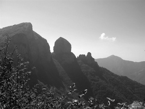 |
| Monte Procinto and its smaller, but similarly shaped, neighbours Procinto Bambino and Bambinetta (click on any image to view in Flickr) |
The base of the via ferrata was located above the path around the base of Procinto and once again it was easier to spot when retracing our steps.
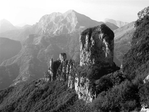 |
| Monte Procinto |
In the picture above the via ferrata starts near the centre of the rock at the top of the tree line, goes up for half the height, then traverses up and left to enter the obvious cleft. The first section was a ladder followed by a very steep section with footsteps cut into the rock. Ascending a via ferrata involves clipping, using two spring-gate karabiners on slings attached to your harness, to a chain or wire rope at the side of the route. The twin clips ensure that one is always attached whilst passing connection points. The first thing you notice compared to climbing is that you are not ‘safe’ in the case of a fall until you pass the second fixed point on the rope. Another thing is that when you reach the fixing point, the karabiners always have to be dragged up from behind you, so progress is not as quick as you expect. At the top of the steep section was an easy path cut into the rock that led into a cleft in the mountain and a short section of grade two scrambling, made safer by the chain. Above this a path wound its way through the trees to the flat top. Like most Italian mountains, Procinto – at 1177m slightly shorter than Snowdon – has an iron cross at the top. This one showed evidence of many lightning strikes in its life. Whist enjoying a well-earned sandwich we signed the visitor’s book that is stored in a tin on the top. Given its prominent location the views for the top were spectacular, including a better view of the face on Monte Nona and across the Monte Forato ridge, scene of the next days walk (foreground from bottom right in the photograph below), to Pania del Croce. One good thing about walking in this area is that it is nowhere near as busy as the Lake District or Snowdonia. We had met a couple descending the via ferrata as we arrived but other than those, the only people we met all day were two members of the regional mountain rescue team climbing on the far side of Procinto near some small caves and a small group of elderly ramblers when we returned to the pass.
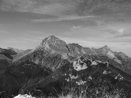 |
| Monte Forato from M Procinto |
Day three started from the same point but wound around the back of Monte Nona to a pass called Foce di Petrosciana from where it started the climb up the ridge of Monte Forato (foreground in the photograph above). The right side was moderately steep and wooded whilst the left side was mostly a sheer drop, but with fantastic views across the valley. After about 20 minutes we reached the steep section, obviously where the via ferrata started. Once again we spent time wandering back and forth along the lower path, (you can do this route without the via ferrata) trying to find the start, only to find the sign after we’d passed it and again it was more obvious from the ‘wrong’ side. The first section was quite steep, with a few tricky bits and the odd step sideways across the big drop, but the holds were mostly good (my first taste of climbing limestone). Once passed, the slope eased and later became (relatively) level (Pic. 4) and the views even more dramatic
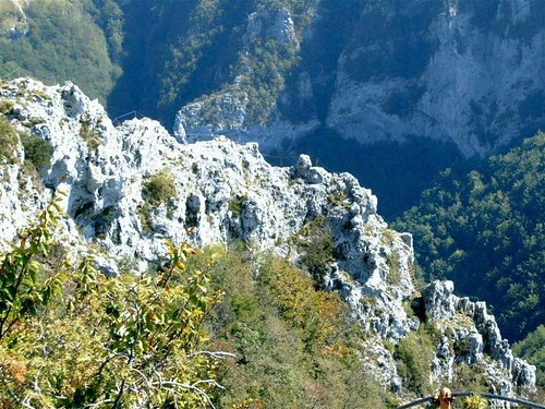 |
| Monte Forato via ferrata |
It was also possible to see the sea to the west and the hill town of Barga off to the east. At one point the undulations of the ridge gave Adrian the chance to get high above me and photograph me crossing the narrowest section, with steep drops to both sides.
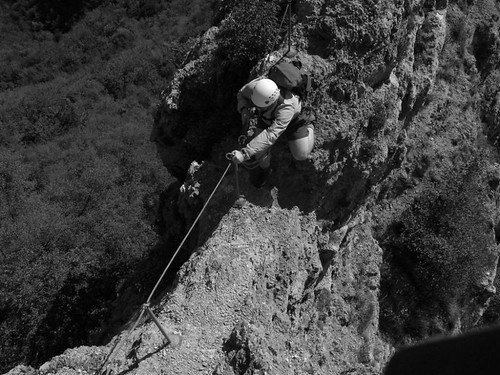 |
| Steep drops |
For me it was on this section that the via ferrata came into its own as I doubt that I’d have attempted it without the wire. At the end of the ridge the path wandered into the woods and then up to the southern peak which gave us our first sight of Monte Forato’s (‘the pierced mountain’) most significant feature, a rock arch about 40m wide.
Its size and alignment is such that it is visible with binoculars from Barga, over 12km away. After sliding our way down through the woods to the lower path (the real route was not obvious form above) we reached the end of the arch and Adrian sauntered across and back over the 300m drop only to have to go back out again since my camera battery had packed up when he was halfway across (see below)!
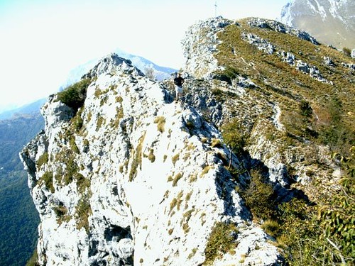 |
| Adrian mid-arch Monte Forato |
We took the lower route back, including an unintended diversion along a spur because of more obscured signs.
After an easy day in and around Lucca, the remainder of the trip was affected by varying amounts of rain. One day involved a drive along great mountain roads though Bagna di Lucca (Lucca Spa) and some high villages. On the final day we drove to the northern end of the Apuane region. There the peaks are higher and more rugged but unfortunately, although the weather low down was reasonable, all the peaks were in cloud. Still, it leaves more for next time!
Kearton
